Sunday, August 5, 2012

The first Palmer stop - Genesse anyone?

We arrived in Palmer for the first time back on the 26th of July.  After checking in at the RV Park we headed over to the Palmer Golf Course.  I joined up with 2 other guys who were walking the course and on the second hole a single player riding a cart caught up with us.  We let him play through and I couldn't help but notice that the basket on his cart was filled with Genny Cream Ale's.  This really really surprised me as I hadn't seen Genesse Beer since leaving New York way back in 79.

I asked him if he had imported those from New York and he told me that ne had purchased them at a place called the Brown Jug right here in Wassilla Alaska.  He also kindly offered myself and my playing partners a can, which of course I took him up on.


The next day we went to visit the Independence mine (I'll post some pics and a write up on that someday) then drove to the Brown Jug.  The guy was right, Genny was everywhere!


I didn't even know there was a Genny Ice or Light!

Oh, and here's one more picture.


Is? Was? apparently no difference in Alaska!

Happy Sunday

We are back in Palmer this Sunday morning.  We stayed in Homer through Thursday morning, then  we drove up and spent the night in Cooper Landing.  (Map)  We left Cooper Landing and, based on the campground reviews in Anchorage, we decided to head up here to Palmer.  (Map)

The campground in Cooper Landing was a Princess Resort facility.  It had a beautiful nature trail that we hiked.  The trail went down a fairly steep hill and then followed the Kenai River.  We did the hike in the morning then headed over to Portage Glacier and took the boat ride over to the glacier.  Here's a couple pictures.


We got lucky with the weather (again) as it was a sunny day!  After the boat ride we headed up towards Beluga Point on the Seward Highway then hung out and waited for the Bore tide to come in.   What's a bore Tide?  Follow this link.

We did all that on Friday - then we drove up to the campground and cooked dinner!  What a long day.

Yesterday we drove into Anchorage and got to visit with my former employers Sam and Maggie Bliss. They live in Florida now but visit their daughter and her family ever summer so we got a chance to stop by and get some advice from Anchorage locals.  After seeing them we went to the street fair/market in downtown Anchorage.

This morning marks the first day of the "head for home" phase of our trip.  We should make it back to Tok today (Map).  We need to be back in Santa Rosa by the 16th of August.

Monday, July 30, 2012

Talkeetna

We arrived in Talkeetna on Wednesday the 24th and the mountain was out.  We caught an exceptionally great time to be there as the weather was beautiful and the mountain stayed out the entire time we were there.  Pictures?  Here's a few.


Alaska Range at Sunset our first night there.


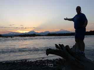
Kim points out Mt. McKinley


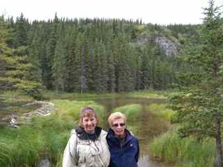
Kim and I in front of the range.


And one final picture in the sunlight.

While in Talkeetna we also took a Jet Boat ride up the Sustina River.  The final destination was the devil's gorge, a class 6 rapid!  Here's the boat and a picture of me at the class 6.


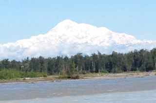
McKinley was out and spectacular so here's a picture of the mountain from the boat.


On the way back the boat stopped and we took a guided walk through a replicated Athbascan fishing village.  They also had a display showing an old school trappers cabin, which is pictured below.


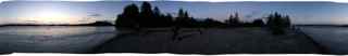
The following is a panoramic picture I took with my iPhone.  Not to sure how it will look in the blog


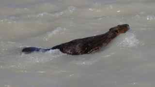
We got to see two new wildlife creatures while in Talkeetna.  The first is this beaver who swam by while we were taking pictures of McKinley on our last day there.


We then saw this swan swimming gracefully across a lake on our way out of town.


 It was then off to Palmer.

Denali National Park


We arrived in Denali National Park on Sunday the 22nd.  Needless to say it was pretty cold.  Kim and I jumped on our bikes and pedaled up to the visitor's center to find out what programs were going on.  After hitting the center we rode back out to the main highway where I posed for the above photo.


On Monday we hiked down to Horseshoe Lake.  It is about a mile and a half down the hill to get there. Above are Kim and her Mom in front of the Lake.  Around the lake there were lots of trees with "Burls" on them.  We couldn't find any information on where they come from but the are basically big bumps on the trees.  You can kind of see them in the picture below.


We attended Ranger programs both nights we were in the Park.  The first night's program was on the raptors in the park and the second was on a cute little critter called the Pica.  After the second nights program we hiked the McKinley-Station trail up to the visitors center then the bike path back to camp.  the next morning it was off to Talkeetna.

Finally, the mountain wasn't out - while we were in the park!  (foreshadowing anyone)

We are in Homer, Ak

Greetings from Homer, the Halibut fishing capital of the world (at least that's what the sign says - I'm not much of a fisherman).  I'm planning to use this post to update on our travels in the last 9 days, then hopefully, get some detailed posts up with pictures.

We left Fairbanks on Sunday the 22nd, driving down to Denali National Park. (Map)  We spent two nights in Denali then headed down to Talkeetna.  (Map)  On the 26th we drove from Talkeetna to Palamer (Map)  From there we headed down to the Kenai Peninsula, staying in the town of Kenai. (Map)  Finally, we drove down here to Homer. (Map)

Highlights from these days on the trip to follow.

Saturday, July 21, 2012

Last day in Fairbanks

We have been in Fairbanks since Wednesday and it has mostly rained on us.  Yesterday the sun broke through briefly and we took advantage of it.  First, we went to the University of Alaska at Fairbanks large animal research center (LARS).  We had lunch as the Musk Oxen hung out in their pen right next to us.  What's a Musk Ox you say?  This is what they look like:


Then, I played nine holes at the Fairbanks golf course.  It's a nice course that is in good shape - for Alaska.   Back home in Az it would be considered not such great shape but it was still fun.  Feeling the need for some exercise I did walk!  Yeah me!

We closed the day by taking a hike around the Creamers Field State Migratory Waterfowl refuge.  While on our hike we came across this interesting mushroom.


It's is called Amanita Muscaria or in English the Fly Agaric.  We looked it up here and found some very interesting stuff.  It's listed as deadly, however it then indicates that it is really a "strong hallucinogen".  It goes on to say that the effects can be "recycled", but you really need to read about that for your self.

Tomorrow we head down to Denali National Park.

Thursday, July 19, 2012

Trip Update

We have been in Alaska for two nights.  We drove from Chicken, Ak to Tok, Ak (Map) on Tuesday and spent last night at the Sourdough campground.  We had lunch yesterday and breakfast today at Fast Eddies at historic mile marker 1313 on the Alaska Highway.  Today we drove up to Fairbanks from Tok. (Map)  In addition to the two moose pictures below we also saw this guy.


We decided it was a wolf and not a husky - What do you think?  Let us know in the comments (then send me an email at dukebauer@gmail.com with your address and we'll send you a postcard)

Here's some pictures of the amazing scenery up here.


And 1 more picture of the moose.


Wednesday, July 18, 2012

Two Moose today!

We drove from Tok to Fairbanks today.  We had an incredible experience as these two moose walked right in front of us!


Internet is kind of slow right now.  Will try to update the trip later tonight.

Monday, July 16, 2012

Giving up on Inuvik, Off to Chicken, Alaska


We drove up the Dempster Highway to the Tombstone visitor center yesterday.  It took us a little over 2 hours to drive the 70 kilometers, the road was incredibly bad.  The Peel river ferry crossing was still closed when we got to the visitor center and the lady there indicated it was raining up in Fort McPherson.  At this point we made the executive decision to give up on Inuvik!

We turned around and headed back here to Dawson City for the night.  We had an excellent dinner at the Jack London grill in downtown - the finest dining room in all of the Yukon.  (It said that on the menu so it has to be true - doesn't it?)

Today we are off to the exciting hamlet of Chicken Alaska.  It's only 174 Kilometers but it's up on to the Top of the World highway which could be just as bad as the Dempster.  Here's the Map.

Sunday, July 15, 2012

Time to move on

We have spent four nights here in Dawson City.  The Dempster Highway up to Inuvik has been closed at the Peel river crossing.  Apparently high water and debris forced the ferry out of the water.  We were told that they had to cut a cable, and that they don't have a replacement.  Hopefully it has been repaired as we are planning to head up to Eagles Plain in the next hour or so. (Map) (If it's still closed we are probably of to Alaska)

We had a good time herein Dawson.  We went to to see the Can-Can girls at Diamond Tooth Gerties on Friday night.  Yesterday, we hiked the ninth street trail, it's a dirt path that travels around the city.   We saw a family of foxes when we got to the Moosehide Slide!


Friday, July 13, 2012

Dawson City, Yukon Territory

So this is my first post ever on our blog!!!

We've been on the road for two weeks today and it's been so exciting with an amazing amount of things to see and do. What is incredible is the fact that we'll be out for 7 weeks which really isn't even enough time to see and do all we really want to do! I am just grateful to be here sharing this experience with my Mom and Doug. How many people really get a chance to spend time with their Mom or Dad making some special memories?!

We're currently in Dawson City, Yukon which is a city so rich in history that every corner has interpretive boards explaining the goings on. Dawson City was the location of one of the world's largest gold rush back in 1898. The story goes that a man by the name of George Carmacks found a 5-dollar pan of course gold back when finding a 10-cent pan was a great find. Word got out and that set off a  gold rush that people had never seen before. People from all over the world made the horrendous journey here which took them months. The sad part is that by the time most stampeders arrived in Dawson, many of them flat broke, all the claims had been staked. Many of the stampeders booked passage home although some remained making money supplying the gold camps. But those who struck it rich, lived lavish lives with some of the finest things money could buy.

Today Dawson City is a small quiet town with about 1,900 people; quite different from the gold rush days when there were as many as 40,000 people! I can't even imagine the chaos in town plus how about the smell! It must of been overwhelming! There are many of the original buildings remaining with stories about the people who owned them or worked there. Of course there was a red light district in town with many interesting stories about them. What a city this must of been!

We are supposed to be heading up to the Northwest Territories today although one of the river crossings we cross by ferry is closed due to high water and debris. It may not sound like a big deal to us, but those towns in the province rely on truckers everyday bringing them supplies so they are virtually cut off now. We've checked the board outside the Northwest Territories center here in Dawson City to find out the status of the river several times today and it's still not looking good. Hopefully tomorrow it'll be open so we can head north. We'll keep you posted!

Happy Friday the 13th everyone-may it be a good luck day. And Happy Birthday Wendy!

Golf on the Top of the World

Yesterday was absolutely beautiful here in the Klondike.  I took advantage of the weather to play the 9 hole golf course just outside of Dawson City.  The course is aptly named the Top of the World Golf course.  Here's a couple pics.


Sign on the Top of the World highway.


5th fairway


6th Teebox, Klondike River in the background


Self portrait on the 7th tee box


Hike up to the clubhouse.

Wednesday, July 11, 2012

The week ahead

We are leaving Whitehorse this morning as we head further north.  Today's trip is from here to Dawson City.  (Map)  We will be there two nights, hoping to play golf at the Top of the World Golf course and take in the Diamond Tooth Gertie show while we are there.

Then it's off to Inuvik. (Map)  From Inuvik the plan is to take a plan up to Tuktoyaktuk, it's so far off the grid that there are no roads to get up there.  Here's a Map of the planned flight.  Internet service will be sketchy to none existent for the next week or so.

Tuesday, July 10, 2012

Wildlife Photos

Lots of wildlife along the way.  Here's some pics.